did-you-know? rent-now

Amazon no longer offers textbook rentals. We do!

did-you-know? rent-now

Amazon no longer offers textbook rentals. We do!

We're the #1 textbook rental company. Let us show you why.

9780897325653

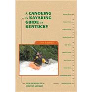
A Canoeing and Kayaking Guide to Kentucky

by ;
  • ISBN13:

    9780897325653

  • ISBN10:

    0897325656

  • Edition: 5th
  • Format: Paperback
  • Copyright: 2004-06-10
  • Publisher: Menasha Ridge Pr
  • Purchase Benefits
  • Free Shipping Icon Free Shipping On Orders Over $35!
    Your order must be $35 or more to qualify for free economy shipping. Bulk sales, PO's, Marketplace items, eBooks and apparel do not qualify for this offer.
  • eCampus.com Logo Get Rewarded for Ordering Your Textbooks! Enroll Now
List Price: $16.95

Summary

With approximately 54,000 miles of streams and rivers, Kentucky has more miles of running water than any state except Alaska. Wet your paddling blade and whet your paddling appetite with the authority on paddling the waterways of Kentucky—A Canoeing & Kayaking Guide to Kentucky. Researched and written by veteran outdoor writers and paddlers Bob Sehlinger and Johnny Molloy, A Canoeing & Kayaking Guide to Kentucky is as vital to enjoying Kentucky’s waterways as the boat itself. From the coal fields of Eastern Kentucky to Kentucky’s western border along the Mighty Mississippi, this redesigned and completely updated guide to paddling the creeks, rivers, and coastal waterways of the Bluegrass State covers thousands of miles of paddling that range in difficulty from scenic floats down the Cumberland to whitewater runs of the Russell Fork. New maps, new river profiles, completely updated contact information, at-a-glance data that includes class, length, time, gauge, level, gradient, volume, and ratings for solitude and scenery make this guide an indispensable river companion.
Author Biography

A native of Kentucky, Bob Sehlinger has led canoeing trips throughout eastern North America and is the former president of the Eastern Professional River Outfitters Association. He is the creator of the Unofficial Guide travel series and a recipient of the Lowell Thomas Gold Award for journalistic excellence. Founder and publisher of Menasha Ridge Press, Sehlinger lives in Birmingham, Alabama, where he enjoys mountain biking and playing the drums.

Johnny Molloy is an outdoor writer based in Johnson City, Tennessee. He has averaged over 100 nights in the wild per year since the early 1980's, backpacking and canoe camping throughout the country. He has written numerous hiking and tent camping guides for the southeastern states, Wisconsin and Colorado.

Table of Contents

Map List ix
Acknowledgments xii
Introduction 1(1)
The Drainages of Kentucky 2(2)
Kentucky Wild Rivers System 4(2)
Rating River Difficulty 6(1)
American Whitewater River Classification System 7(1)
Using River Gauges 8(1)
Water Lever Sites 8(1)
Hazards and Safety 9(1)
Winter Paddling 9(1)
Cold-Weather Survival 10(1)
Paddler Information 11(1)
Rating the Paddler 11(4)
Knowing Your Rights on the River 15(1)
Environmental Concerns 16(1)
Using This Guide 17(2)
Map Legend 19(2)
part One STREAMS OF THE EASTERN COAL FIELDS
Russell Fork
21(4)
Levisa Fork of the Big Sandy Fork
25(5)
Johns Creek
30(2)
Little Sandy River
32(4)
Tygarts Creek
36(2)
part Two THE LICKING RIVER AND ITS TRIBUTARIES
North Fork of the Licking River
38(2)
Middle Fork of the Licking River
40(6)
Hinkston Creek
46(2)
Stoner Creek
48(2)
South Fork of the Licking River
50(3)
Licking River
53(3)
part Three THE KENTUCKY RIVER AND ITS TRIBUTARIES
North Fork of the Kentucky River
56(8)
Middle Fork of the Kentucky River
64(4)
Red Bird River
68(2)
South Fork of the Kentucky River
70(3)
Kentucky River below the Forks
73(13)
Red River
86(6)
Four Mile Creek
92(2)
Lower Howard's Creek
94(2)
Boone Creek
96(2)
Hickman Creek
98(4)
Jessamine Creek
102(2)
Dix River
104(2)
Hanging Fork of the Dix River
106(2)
Gilbert Creek
108(2)
Benson Creek
110(3)
South Fork of Elkhorn Creek
113(1)
North Fork of Elkhorn Creek
114(2)
Elkhorn Creek
116(2)
Eagle Creek
118(2)
part Four CREEK DRAINAGES OF MADISON COUNTY
Calloway Creek
120(2)
Muddy Creek
122(3)
West Fork/Main Stem of Otter Creek
125(2)
East Prong of Otter Creek
127(3)
Silver Creek
130(3)
Tates Creek
133(2)
part Five THE CUMBERLAND RIVER AND ITS TRIBUTARIES
Poor Fork of the Cumberland River
135(2)
North Fork of the Cumberland River
137(8)
Laurel River
145(2)
Rockcastle River
147(6)
Buck Creek
153(2)
Big South Fork Gorge of the Cumberland River (Tennessee)
155(2)
Big South Fork of the Cumberland River (Kentucky)
157(3)
Little South Fork of the Cumberland River
160(2)
Rock Creek
162(2)
Cumberland River from Wolf Creek Dam to the Tennessee Border
164(2)
part Six THE SALT RIVER SYSTEM OF THE WESTERN BLUEGRASS
Salt River
166(4)
Plum Creek
170(2)
Floyds Fork of the Salt River
172(3)
Rolling Fork of the Salt River
175(2)
Beech Fork of the Rolling Fork of the Salt River
177(2)
part Seven HEADWATERS OF THE GREEN RIVER
Green River
179(7)
Russell Creek
186(2)
Barren River
188(4)
Drakes Creek
192(3)
Gasper River
195(2)
Little Barren River
197(3)
Nolin River
200(4)
part Eight STREAMS OF THE WESTERN COAL FIELDS
Tradewater River
204(2)
Pond River
206(2)
Panther Creek
208(2)
Rough River
210(4)
Mud River
214(2)
Green River from Houchins Ferry to the Ohio River
216(5)
Part Nine STREAMS OF LAND BETWEEN THE LAKES
Cumberland River north of Lake Barkley
221(2)
Tennessee River north of Kentucky Lake
223(1)
Muddy Fork of the Little River
224(2)
Little River
226(1)
Land Between the Lakes Paddle Route
227(5)
part Ten STREAMS OF THE JACKSON PURCHASE
Bayou du Chien
232(2)
Obion Creek
234(2)
Mayfield Creek
236(2)
Clarks River
238(2)
part Eleven WATERS OF SPECIAL MENTION
Ballard Wildlife Management Area
240(2)
Red River of Logan County
242(2)
Harrods Creek of Oldham and Jefferson Counties
244(2)
Little Kentucky River
246(1)
Other Paddling Streams
246(3)
Appendices
Appendix A: American Whitewater Safety Code
249(7)
Appendix B: Outfitters
256(2)
Appendix C: Clubs
258(11)
Appendix D: Glossary
269
Index 261(6)
About the Authors 267

Supplemental Materials

What is included with this book?

The New copy of this book will include any supplemental materials advertised. Please check the title of the book to determine if it should include any access cards, study guides, lab manuals, CDs, etc.

The Used, Rental and eBook copies of this book are not guaranteed to include any supplemental materials. Typically, only the book itself is included. This is true even if the title states it includes any access cards, study guides, lab manuals, CDs, etc.

Excerpts

This section of the river flows through the Daniel Boone National Forest. It is extremely remote and makes a good canoe-camping run at moderate water levels (500-1100 cfs) and a fair whitewater run at higher levels (1100-1900). This section has been designated as a Kentucky Wild and Scenic River.

As the river passes Williamsburg, rock replaces the muddy bottom found in upper sections of the river, and it continues to widen in places to almost 200-feet across. The gradient also increases, creating some mild whitewater (Class II), with boulders in the stream and some shoals spanning the entire width of the river. The current runs swift and continuously, with very few pools. Boulders line the banks in increasing numbers and some flat, accessible terraces have been carved along the streamside.

As the Cumberland begins to enter the deep gorge that will carry it over the falls and beyond to lake Cumberland, exposed rock palisades become visible on the right. About one mile upstream of the falls, the river curves sharply to the left and the KY 90 bridge becomes visible downstream. Move to the right of the river for the take-out on the upstream side of the bridge (at the picnic ground and parking lot). Failure to move promptly to the right can have tragic consequences for the unlucky or inexperienced.

One of the larger shoals (Class II) of this section is situated across the entire river just upstream of the take-out. If you run the shoals on the left, and fill up or capsize, you will find yourself in the main current heading for the entrance rapids to Cumberland Falls several hundred yards downstream. If you run the shoals on the right and take water or turn over, you will be in much slower current. Except at excessive levels (1900 cfs or higher), you will be washed into the bank as the river narrows near the bridge, or alternately, swept downstream past the bridge into a huge eddy that forms along the bank near the visitor's parking lot.

Excerpted from A Canoeing and Kayaking Guide to Kentucky by Bob Sehlinger, Johnny Molloy
All rights reserved by the original copyright owners. Excerpts are provided for display purposes only and may not be reproduced, reprinted or distributed without the written permission of the publisher.

Rewards Program