rent-now

Rent More, Save More! Use code: ECRENTAL

5% off 1 book, 7% off 2 books, 10% off 3+ books

9780008313142

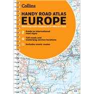
Collins Handy Road Atlas Europe

by Unknown
  • ISBN13:

    9780008313142

  • ISBN10:

    0008313148

  • Format: Spiral Bound
  • Copyright: 2020-11-01
  • Publisher: Collins
  • Purchase Benefits
  • Free Shipping Icon Free Shipping On Orders Over $35!
    Your order must be $35 or more to qualify for free economy shipping. Bulk sales, PO's, Marketplace items, eBooks and apparel do not qualify for this offer.
  • eCampus.com Logo Get Rewarded for Ordering Your Textbooks! Enroll Now
List Price: $12.75

Summary

Handy road atlas of Europe with lie-flat spiral binding. Scenic routes are plotted on the maps. Scale: 34 miles to 1 inch. Euroroutes and motorways are easily distinguished. International road classifications, road distances and land height are shown by attractive layer tints. Features: Route planning maps at 1:6,340,000 with political coloring, country fact file, information on international road signs, main road maps at 1:2,174,000. Includes Ireland, France and Hungary motorways,

Author Biography

Explore the world through accurate and up-to-date mapping with Collins Maps.

Supplemental Materials

What is included with this book?

The New copy of this book will include any supplemental materials advertised. Please check the title of the book to determine if it should include any access cards, study guides, lab manuals, CDs, etc.

The Used, Rental and eBook copies of this book are not guaranteed to include any supplemental materials. Typically, only the book itself is included. This is true even if the title states it includes any access cards, study guides, lab manuals, CDs, etc.

Rewards Program